| |
|
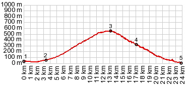
1.(00.0km,020m) START-END EAST:a sideroad begins on the west side of Motril
2.(03.4km,050m)route stays left in Rio Guadalquivir
3.(13.0km,550m)TOP: junction with GR5207 to the next higher summit point in Lujar
4.(17.0km,320m)road skirts Gualchos on left
5.(23.9km,020m)Castell de Ferro
|