| |
|
|
|
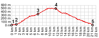
1.(00.0km,3m) START-END EAST ALT: port in Nice
2.(01.4km,19m) START-END EAST: route turns right up Boulevard Bischofsheim
3.(06.9km,327m) Col de Quatre Chemins
4.(11.5km,507m) TOP: Col d'Eze
5.(21.0km,12m) START-END WEST: coast near Cap d'Ail
|
|
1.(00.0km,3m) START-END EAST ALT: port in Nice 2.(01.4km,19m) START-END EAST: route turns right up Boulevard Bischofsheim 3.(06.9km,327m) Col de Quatre Chemins 4.(11.5km,507m) TOP: Col d'Eze 5.(21.0km,12m) START-END WEST: coast near Cap d'Ail
|