| |
|
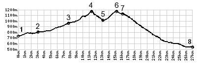
1.(740m,00.0km) START-END
SOUTH:Boëge
2.(790m,03.0km)Villard
3.(950m,07.7km)Habère-Poche
4.(1164m,11.0km)Col Des Arces
5.(1000m,12.8km)downhill in right connects with Lulin,a
short loop option
6.(1175m,14.8km)TOP: C3 La Plagne s(u) and turnoff to Tres
Le Mont
7.(720m,15.5km)Col du Feu(shp)
8.(530m,26.6km)START-END NORTH: Allinges