| |
|
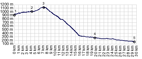
1.(00.0km,0180m)START-END EAST:St Jean
Pied de la Port, south gate
2.(11.0km,0320m)jct with D428, coming down from Col de
Arnosteguy
3.(19.8km,1160m)TOP: Arthaburo s(u), immediately
before turnoff to Errozate s(u)
4.(24.2km,1020m)turnoff south to Spanish border and
Errozate s(u)
5.(27.3km,1135m)Col de Zurzai
6.(29.9km,1000m)Chalet de Irati
7.(32.8km,1135m)Col de Burdinkurutcheta
8.(55.0km,0170m)START-END WEST:St Jean Pied de la
Port, north side
|