| |
|
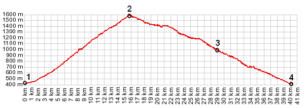
1.(00.0km,412m) START-END 1: Ugine,
2.(15.7km,1581m) TOP: Col de l'Arpettaz
3.(28.9km,970m) profile continues straight here; left leads to the Gorge of the Arly further north
4.(40.1km,412m) START-END 2: same as point 1
|
|
1.(00.0km,412m) START-END 1: Ugine, 2.(15.7km,1581m) TOP: Col de l'Arpettaz 3.(28.9km,970m) profile continues straight here; left leads to the Gorge of the Arly further north 4.(40.1km,412m) START-END 2: same as point 1
|