| |
|
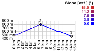
1.(00.0km,0500m)START-END WEST:road jct
eat of Cazaunous
2.(06.6km,0799m)TOP:Col des Ares
3.(14.1km,0470m)START-END EAST: low point, just north
of Chaum
|
|
1.(00.0km,0500m)START-END WEST:road jct
eat of Cazaunous
|