| |
|
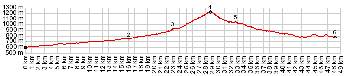
1.(00.0km,0600m)START-END EAST ALT: Puente La Reina de Jaca over the Rio Aragon
2.(16.1km,0750m)START-END EAST: profile turns right to Jasa
3.(23.0km,0920m)Jasa
4.(28.8km,1227m)TOP: Alto de Aisa s(u)
5.(32.8km,1030m)upper turnoff to Aisa
6.(48.1km,0780m)START-END WEST: bridge over Rio Aragon tributary, several km before Jaca
|