| |
|
|
|
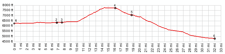
1.(6260ft,mile00.0) START-END EAST: South Lake Tahoe lakefront
2.(6350ft,mile06.7) Pioneer Trail merges from west
3.(6360ft,mile07.5) jct with Ca50: Lincoln Highway; profile stays left on US89
4.(7790ft,mile16.1) TOP: highest point on road, just west of jct with dirt road; official elevation of pass is 7740ft
5.(7080ft,mile18.7) route turns left down, when joining Ca88, joining Carson Pass Highway
6.(4780ft,mile32.0) START-END WEST: jct Ca88 - Ca206
|
|