|
|
|
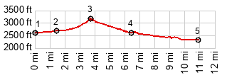
1.START-END WEST:low point on Kinney Rd at jct with Hi Grass Rd
2.profile turns east from Kinney Rd onto Gates Pass Rd
3.TOP, Gates Pass, 3170ft
4.end of Gates Pass Rd. Profile continues on Speedway Blvd
5.START-END EAST:Speedway Blvd crosses Santa Cruz River and its bikepath
|