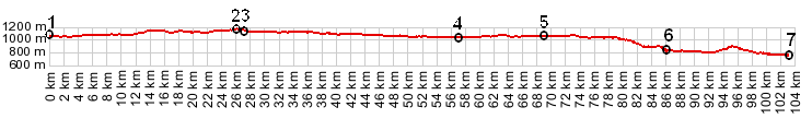
01.(km00.0,1050m) START-END EAST: Jasper
02.(km26.0,1130m) TOP: Alberta - British Columbia boundary
03.(km27.0,1130m) TOP: Some maps mark the pass here
04.(km57.0,1020m) east end of Slave Lake
05.(km68.8,1050m) west end of Slave Lake
06.(km86.2,830m) START-END WEST ALTERNATE: Mount Robson trailhead / visitor
center
07.(km103.0,740m) START-END WEST: Tete Jaune Cache
profile is half size, compared with other profiles in these pages, but same
vertical exageration (9.1).