| |
|
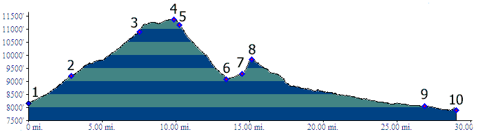
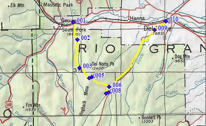
01.(8150ft,mile00) START-END WEST: jct Del Norte Peak Road (FR345) - US160, east of South Fork.
02.(9220ft,mile04) route stays right onto FR350
03.(10900ft,mile08) Profile turns onto FR358 on left. Profile between here and point 4 is an approximaton. Turn off right onto TR899.
04.(11380ft,mile11) TOP
05.(11160ft,mile11) approximate location, jct with FR345. This route crosses the road and continues on TR898
06.(9100ft,mile15) trail reaches Pinos Creek and turns upstream
07.(9209ft,mile16) route crosses Pinos Creek.
08.(9830ft,mile17) trails joins FR14 and turns left towards Del Norte
09.(8040ft,mile27) START-END EAST ALTERNATE: jct FR14 -FR14A. FR14A is a short cut towards west.
10.(7900ft,mile29) START-END EAST: jct FR14 -US160, west of Del Norte