| |
|
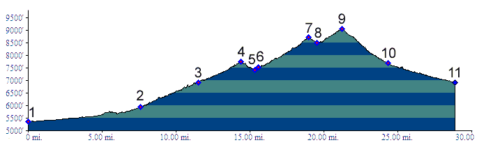
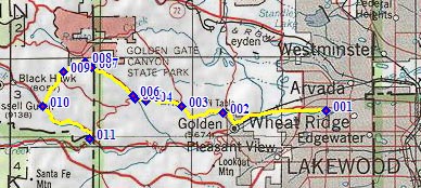
01.(5360ft,mile00) START-END EAST
ALT: jct: Clear Creek bike path - Kippling Ave.
02.(5930ft,mile08) START-END EAST: beginning of Golden Gate Canyon Road, just north of Golden
03.(6920ft,mile12) Crawford Gulch Road diverts on right
04.(7750ft,mile15) Golden Gate Pass
05.(7430ft,mile16) intermediate low point
06.(7530ft,mile16) Robinson Hill Road joins on left
07.(8730ft,mile20) Golden Gate Canyon summit(u)
08.(8500ft,mile20) route turns onto Smith Hill (dirt) on left
09.(9050ft,mile22) TOP
10.(7670ft,mile25) START-END WEST:route joins busy Co119. Profile continues left downhill.
11.(6920ft,mile29)START-END WEST ALT: JCT Co119 - US6 in Clear Creek Canyon.