|
|
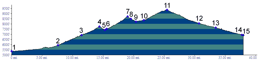
01.(5360ft,mile00) START-END EAST ALT: jct:
Clear Creek bike path - Kippling Ave.
02.(5930ft,mile08) START-END EAST: beginning of Golden
Gate Canyon Road, just north of Golden
03.(6920ft,mile12) Crawford Gulch Road diverts on right
04.(7750ft,mile15) Golden Gate Pass
05.(7430ft,mile16) intermediate low point
06.(7530ft,mile16) Robinson Hill Road joins on left
07.(8730ft,mile20) Golden Gate Road summit(u)
08.(8500ft,mile20) Smith Hill (dirt) road diverts on left
09.(8220ft,mile21) START-END EAST ALTERNATE: Golden Gate
Park Visitor Center, profile continues straight
10.(8360ft,mile22) Mountain Base Road diverts on right
11.(9350ft,mile26) TOP: jct: Golden Gate Canyon Road -
Peak to Peak Hiway. Profile turns left
12.(8060ft,mile31) upper turnoff to Blackhawk on right
13.(7650ft,mile34) turnoff up Smith Hill Road on left
(dirt).
14.(6950ft,mile38) turnoff up Douglas Mountain Drive on
left (dirt).
15.(6920ft,mile38) START-END: WEST: jct US6 - Co119 (Peak
to Peak Highway).
|