| |
|
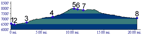
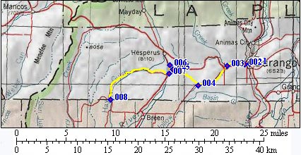
1.(6550ft,mile00) START-END EAST: Durango
2.(6460ft,mile01) low point crossing Animas River west of Durango
3.(6680ft,mile03) turn left up Wildcat Canyon
4.(7200ft,mile07) turn right up dirt road to Old Hesperus Pass
5.(8019ft,mile11) TOP: Old Hesperus Pass. Road is paved from here on
6.(7930ft,mile11) US160 and (new) Hesperus Pass is towards right. But profile continues to left.
7.(7830ft,mile12) go right on dirt road down Hay Gulch
8.(7080ft,mile21) START-END WEST: junction between 116rd and 105rd. Suggested day ride continues right towards Cherry Creek road.