| |
|
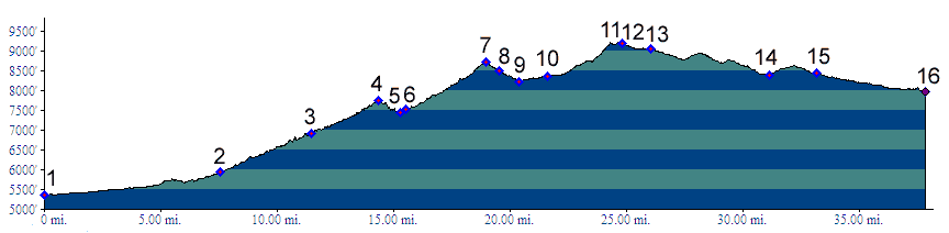
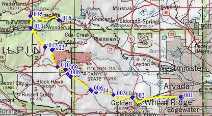
01.(5360ft,mile00) START-END SOUTH ALT: jct: Clear Creek bike path - Kippling Ave.
02.(5930ft,mile08) START-END SOUTH: beginning of Golden Gate Canyon Road, just north of Golden
03.(6920ft,mile12) Crawford Gulch Road diverts on right
04.(7750ft,mile15) Golden Gate Pass
05.(7430ft,mile16) intermediate low point
06.(7530ft,mile16) Robinson Hill Road joins on left
07.(8730ft,mile20) Golden Gate Canyon Rd s(u)
08.(8500ft,mile20) Smith Hill (dirt) road diverts on left
09.(8220ft,mile21) START-END WEST ALTERNATE: Golden Gate Park Visitor Center, profile continues straight.
10.(8360ft,mile22) Mountain Base Road diverts on right
11.(9230ft,mile) TOP
12.(9190ft,mile) route turns left down Gap Road
13.(9060ft,mile) route turns right onto paved Co119, Peak to Peak Highway
14.(8400ft,mile) START-END NORTH ALT: low point just south of Rollinsville
15.(8440ft,mile) route turns right down onto Co72, down Beaver Creek, towards Coal Creek Canyon
16.(7960ft,mile) START-END NORTH: Pinecliffe