| |
|
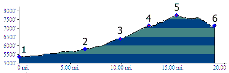
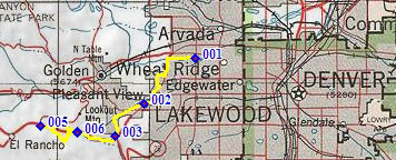
01.(mile00,5360ft) START-END NORTH: jct Clear Creek bikepath - Kipling Ave, Wheat Ridge
02.(mile07, 5800ft) jct: I70 - Colfax Ave, Lakewood
03.(mile10,6400ft) jct: US40 - Mount Vernon Canyon
04.(mile13,7150ft) junction with Grapevine Road on other side of I70
05.(mile16,7740ft) TOP: route crosses I70 on bridge
06.(mile19,7160ft) START-END SOUTH: same as point 4