| |
|
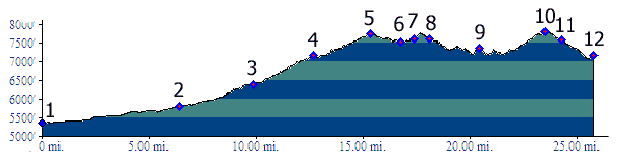
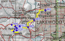
02.(mile07, 5800ft) jct: I70 - Colfax Ave, Lakewood
03.(mile10,6400ft) jct: US40 - Mount Vernon Canyon
04.(mile13,7150ft) junction with Grapevine Road on other side of I70; profile continues up Mount Vernon Canyon parallel to I70.
05.(mile16,7740ft) Mount Vernon Canyon - Genesee Trail Rd s(u): route crosses I70 on bridge and turns down and back east
06.(mile17,7530ft) Genesee Village Rd diverts on left; profile continues straight
07.(mile18,7610ft) go right up Genesee Vista Rd
08.(mile19,7610ft) route stays right: begin Foothills Dr North, while Genesee Vista Rd stays left
09.(mile21,7360ft) route stays right: begin Montane Drive, while Foothills Dr South stays left
10.(mile24,7790ft) TOP: highest point on Montane Drive
11.(mile25,7590ft) turn right onto Genesee Ridge Rd
12.(mile26,5360ft) START-END EAST 2: same as point 4, bridge over I-70 at Grapevine Rd