| |
|
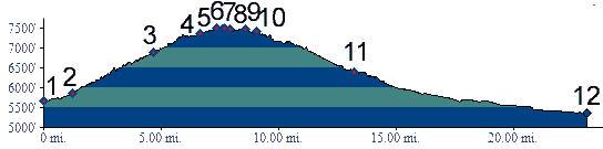
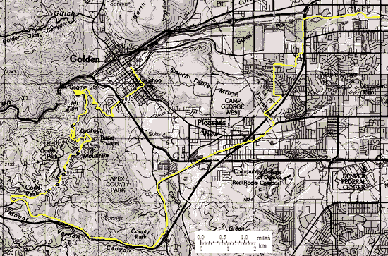
01.(5650ft,mile00) START-END EAST-NORTH: Golden: west end of Coors brewery
02.(5870ft,mile02) START-END EAST-NORTH ALTERNATE: start of Lookout Mountain Road, off US6
03.(6880ft,mile05) Windy Saddle
04.(7360ft,mile07) eastern turnoff to Lookout Mtn Nature Center summit(u) on right
05.(7500ft,mile08) TOP: point of highest altitude
06.(7480ft,mile08) western turnoff to Lookout Mtn Nature Center summit(u) on right
07.(7490ft,mile08) Paradise Road turns off on left
08.(7470ft,mile09) Charros Drive turns off on left
09.(7460ft,mile10) road to Mount Vernon Country Club turns off on right
10.(7410ft,mile10) turn left down Mount Vernon Canyon
11.(6400ft,mile14) START END EAST-SOUTH 1 ALTERNATE: turn left down US40, which becomes Colfax Ave
12.(5360ft,mile23) START END EAST-SOUTH 1: jct: Clear Creek bike path - Kipling Ave