| |
|
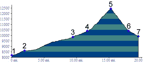
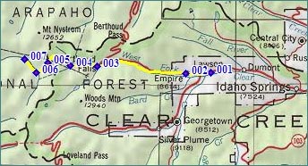
1.(8210ft,mile00) START-END EAST: jct: US40 - I70, east of Empire
2.(8610ft,mile02) START-END EAST ALTERNATE: Empire
3.(9870ft,mile10) Jones Pass road leaves US40 to Berthoud Pass on left
4.(10420ft,mile12) road up Bulter Gulch leaves on left; stay right
5.(12451ft,mile16) TOP: Jones Pass
6.(10424ft,mile18) START-END WEST ALTERNATE: end of switchbacks at Bobtail mine, and end of dirt road
7.(9930ft,mile20) START-END WEST: trail becomes difficult to follow