| |
|
-

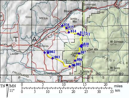
1 (mile00,5680ft) START/END-NORTH: 39.00 Rd, north of Crawford, take good dirtroad heading east
2 (mile01,5730ft) go right at T intersection
3 (mile03,5910) stay left
4 (mile08,6970ft) go left around Needle Rock
5 (mile09,7280ft) go left, up left side of valley on jeep trail
6 (mile11,7650ft) stay on lower route to the right, now a trail
7 (mile13,8410ft) turn left up hill
8 (mile15,9670ft) route splits. Higher summit is on left. Routes converge at point 10. The profile shows route to the left
9 (mile15,9760ft) TOP - take the right fork. Route descends soon.
10 (mile16,9560ft) If you went to the higher summit, stay left. Otherwise continue straight.
11 (mile19,7530ft) take the left at the T onto a good jeep trail
12 (mile19,7390ft) Lone Cabin Reservoir
13 (mile20,7650ft) take left at T
14 (mile23,6270ft) take right at T
15 (mile24,5870ft) take left at T
16 (mile25,5690ft) START/END-SOUTH: Paonia
-