| |
|
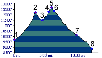
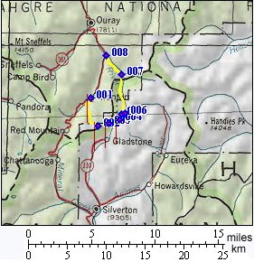
1.(9700ft,mile00) START-END SOUTH: Ironton on Red Mountain Pass road
2.(12217ft,mile03) Corkscrew Pass
3.(11500ft,mile05) Cement Creek road joins from right
4.(12290ft,mile06) trail to Sunnyside Saddle leaves on right
5.(12407ft,mile07) TOP: Hurricane Pass
6.(12300ft,mile07) profile continues left down Poughkeepsie Gulch. Main road continues right up California Pass.
7.(10140ft,mile10) jeep trail from Engineer Pass joins from right
8.(8860ft,mile12) START-END WEST: Red Mountain Pass road