| |
|
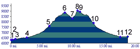
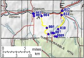
01.(6310ft,mile00) START-END WEST:
Gypsum
02.(6340ft,mile01) right turn onto Valley Road
03.(6400ft,mile01) left turn onto Cooley Mesa Road
04.(6520ft,mile03) right turn onto Spring Gulch Road
05.(7620ft,mile06) stay right at this fork. Left goes to the top of Hardscrabble Mtn.
06.(8859ft,mile08) Hardscrabble Saddle
07.(8300ft,mile10) profile diverges from Abrams Gulch, taking a right. All trails single track.
08.(9066ft,mile11) TOP: point of highest altitude
09.(8950ft,mile12) profile continues left
10.(7890ft,mile13) profile continues right
11.(6600ft,mile18) outskirts of Eagle. End of single track. Beginning of Abrams Gulch Drive
12.(6600ft,mile19) Eagle, intersection with US6