| |
|
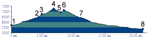
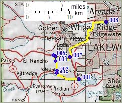
01.(5720ft,mile00) START-END SOUTH: Morrison,
jct C470 - Bear Creek Canyon
02.(6470ft,mile05) profile turns right up South
East Grapevine Road
03.(6760ft,mile05) South East and South West
Grapevine Road join, as well as road up Mount
Morrison
04.(7270ft,mile07) TOP
05.(6940ft,mile08) low point on Genessee Ridge
Road
06.(7150ft,mile09) Genesssee Ridge Road crosses
I70 and joins US40; turn right
07.(6400ft,mile11) START-END EAST ALTERNATE:
turn from Mount Vernon Canyon left onto US40
which becomes Colfax Ave.
08.(5360ft,mile26) START-END EAST: Clear Creek
bike path at Kipling Ave.