| |
|
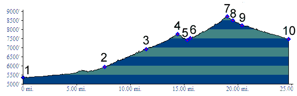
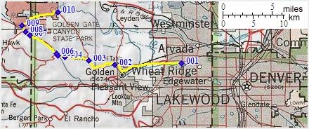
01.(5360ft,mile00) START-END EAST ALT: jct: Clear Creek bike path - Kippling Ave.
02.(5930ft,mile08) START-END EAST: beginning of Golden Gate Canyon Road, just north of Golden
03.(6920ft,mile12) Crawford Gulch Road diverts on right
04.(7750ft,mile15) Golden Gate Pass
05.(7430ft,mile16) intermediate low point
06.(7530ft,mile16) Robinson Hill Road joins on left
07.(8730ft,mile20) TOP: Golden Gate Canyon summit(u)
08.(8500ft,mile20) Smith Hill (dirt) road diverts on left
09.(8220ft,mile21) START-END WEST ALTERNATE: Golden Gate Park Visitor Center, profile continues right down Ralston Creek Road
10.(7490ft,mile25) START-END WEST: low point on Ralston Creek road and extend of pavement