| |
|
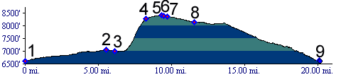
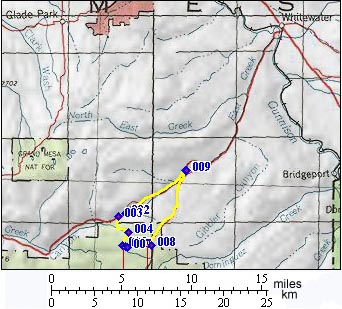
1.(6610ft,mile00) START-END NORTH: junction of Co141 and Divide Road (unpaved)
2.(7048ft,mile06) Unaweep Divide
3.(7000ft,mile07) horsetrail to plateau leaves on left.
4.(8290ft,mile08) junction with barely defined trail to plateau edge towards left. Profile continues towards right.
5.(8420ft,mile10) trail ends at a T junction of double track trails. Continue left.
6.(8380ft,mile10) TOP: Gill Creek Divide
7.(8370ft,mile10) profile continues to left. Both trails will lead to Divide Road.
8.(8140ft,mile12) junction with Divide gravel road. Continue left.
9.(6610ft,mile21) START-END SOUTH: same as point 1