| |
|
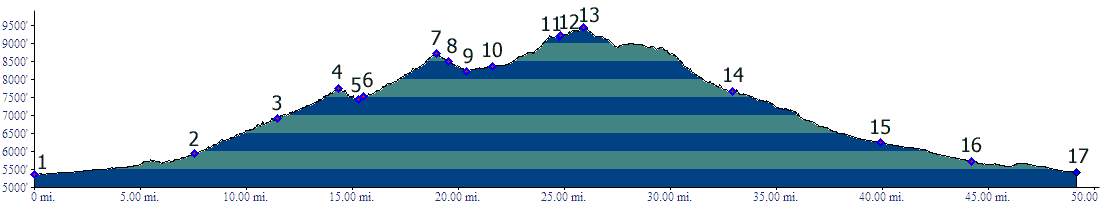
01.(5360ft,mile00) START-END SOUTH ALT: jct: Clear Creek
bike path - Kippling Ave.
02.(5930ft,mile08) START-END SOUTH: beginning of Golden
Gate Canyon Road, just north of Golden
03.(6920ft,mile12) Crawford Gulch Road diverts on right
04.(7750ft,mile15) Golden Gate Pass
05.(7430ft,mile16) intermediate low point
06.(7530ft,mile16) Robinson Hill Road joins on left
07.(8730ft,mile20) Golden Gate Canyon Rd s(u)
08.(8500ft,mile20) Smith Hill (dirt) road diverts on
left
09.(8220ft,mile21) START-END WEST ALTERNATE: Golden Gate
Park Visitor Center, profile continues straight.
10.(8360ft,mile22) profile turns right on Mountain Base
Road
11.(9230ft,mile25) top of Mountain Base Rd(sh)
12.(9190ft,mile25) turn right onto Gap Rd
13.(9460ft,mile27) TOP
14.(7650ft,mile34) turn right down Coal Creek Canyuon
15.(6240ft,mile40) START-END NORTH ALT: jct Coal Creek
Canyon - Co93. Profile continues straight
16.(5730ft,mile45) Profile turns right on Indiana
Street, shortly thereafter left on 82nd Ave Parkway,
then 80th Ave
17.(5430ft,mile49) START-END NORTH: jct 80th Ave -
Wadsworth Blvd