| |
|
-
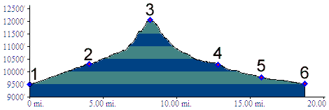
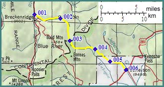
1.(9490ft,mile00) START-END NORTH: junction Co9 - Tiger Run Road, north of Breckenridge
2.(10320ft,mile04) trail up French Gulch continues straight, while dirt road turns right up hill.
3.(12045ft,mile09) TOP: French Pass
4.(10280ft,mile13) approximate junction with Georgia Pass road. Profile continues down valley.
5.(9770ft,mile16) profile continues left to Jefferson. Right fork also leads to US285.
6.(9500ft,mile19) START-END SOUTH: Jefferson
-