| |
|
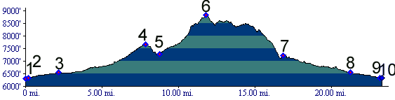
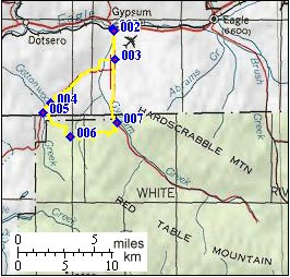
01.(6310ft,mile00) START-END NORTH-WEST: Gypsum
02.(6340ft,mile01) turn right onto Valley Road
03.(6540ft.mile03) turn left direction Cottonwood Pass
04.(7660ft,mile08) top of Blue Hill
05.(7270ft,mile09) turn left onto signed FR529 (Brewster Gulch), slightly beyond the low point between Blue Hill and Cottonwood Pass
06.(8821ft,mile12) TOP: junction of FR529 and FR 430 (Fitzpatrick Gulch), as well as FR430-1A to Old Man Mtn. Route continues towards left on FR430
07.(7220ft,mile17) trail terminates onto Gypsum Valley road. Profile continues downvalley to left.
08.(6540ft,mile22) same as point 3
09.(6340ft,mile23) same as point 2
10.(6310ft,mile24) START-END NORTH-EAST: Gypsum