| |
|
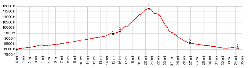
1.(mile00.0,8000ft) START-END EAST-1: jct US285 - CRU56, north of Villa Grove
2.(14.9mile,9450ft) Bonanza
3.(16.1mile,9650ft) profile turns right up steep track, but next tunroff up Squirrel Creek is also an option
4.(20.6mile,11780ft) FR890 Round Mtn(sh)
5.(27.0mile,8580ft)profile turns right onto US285, coming down from Poncha Pass
6.(34.4mile,8110ft)START-END EAST-2: jct US285 - CRNN56 up Peterson Creek
| |