| |
|
|
|
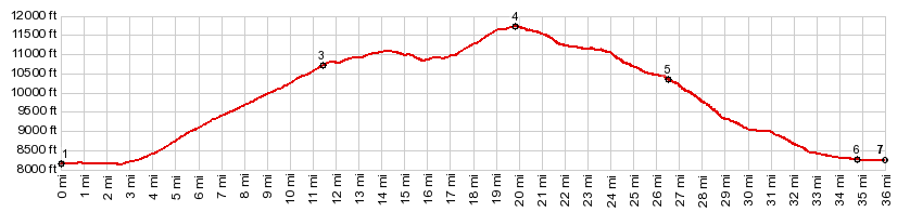
1.(mile00.0,8150ft) START-END EAST: jct US160 - North River Rd, east of South Fork
2.(mile02.8,8150ft)profile turns left up FR630
3.(mile11.4,10710ft)turnoff to lookout point and transmission towers on right
4.(mile19.9,11760ft) TOP: FR611 Alder Creek -Aqua Ramon Rd(sh)
5.(mile26.6,10350ft)route joins FR610
6.(mile36.0,8240ft) START-END WEST: jct Alder Creek Rd - North River Rd, east of South Fork.
|
|