| |
|
-
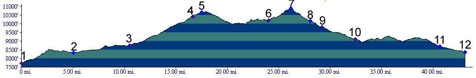
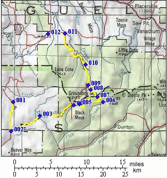
01.(7720ft,mile00) START-END SOUTH: junction of D.00rd down Disappointment Valley and 31.00rd heading north to south
02.(8330ft,mile05) route continues left to Groundhog Reservoir
03.(8740ft,mile11) route continues on right, leaving Groundhog Reservoir
04.(10420ft,mile17) West Beaver Creek Road joins from left. Continue straight.
05.(10650ft,mile18) route over Lone Cone Pass joins from left. Continue straight. (same as point 8 in Lone Cone Pass profile )
06.(10190ft,mile25) track over East Lone Cone Pass switches back on left. Take it. (same as point 9 in Lone Cone Pass profile ).
07.(10890ft,mile26) TOP: East Lone Cone Pass
08.(10160ft,mile28) route over Lone Cone Pass joins from left. Continue straight.
09.(9810ft,mile30) Beaver Creek Road joins from left. Continue straight.
10.(9100ft,mile33) Beaver Park ( same as point 5 in Lone Cone Pass profile ).
11.(8690ft,mile41) route joins Beef Trail Road. Profile continues to left at this T. (same as point 3 in Lone Cone Pass profile ).
12.(8370ft,mile43) START-END NORTH: junction: Beef Trail Road and unofficial Lone Cone SWA summit.
-