| |
|
-
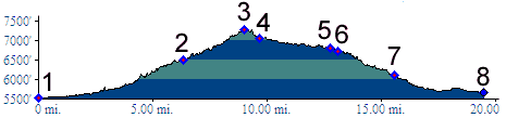
01.(5530ft,mile00) START-END SOUTH: jct Deer Creek Canyon Road - Wadsworth Boulevard west of Chatfield Reservoir, Lakewood
02.(6500ft,mile07) jct with South Deer Creek Canyon Road; profile stays right
03.(7280ft,mile10) TOP
04.(7070ft,mile10) Turkey Creek Canyon Road takes off on left
05.(6800ft,mile13) profile turns right down US285
06.(6730ft,mile13) Road to Dix Saddle aka Parmallee Gulch takes off on left
07.(6110ft,mile16) START-END NORTH: Morrison exit on US285
08.(5660ft,mile20) END NORTH ALTERNATE: Simms Street exit on US285

-