| |
|
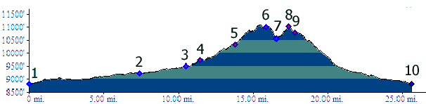
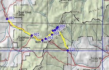
01.(8810ft,mile00) START-END WEST ALTERNATE: jct Co 114: North Cochetopa Pass Rd - NN14 to Cochetopa Pass
02.(9230ft,mile08) Archuleta Creek Rd on right leads to NN14
03.(9480ft,mile11) lowest access point for Colorado Trail south
04.(9730ft,mile12) START-END WEST: Begin Colorado Trail. Trail heads north from Co114 on FR785; profile between here and top is an aproximation.
05.(10330ft,mile14) Colorado Trail diverts from FR785, turning left on single track trail
06.(11019ft,mile16) TOP
07.(10540ft,mile17) intermediate low point
08.(11010ft,mile18) intermediate summit; profile between here and next point is an approximation
09.(10780ft,mile18) START-END EAST: End Colorado Trail. Turn right onto FR790
10.(8800ft,mile26) START-END EAST ALTERNATE: jct FR810 - Co114 to North Cochetopa Pass