| |
|
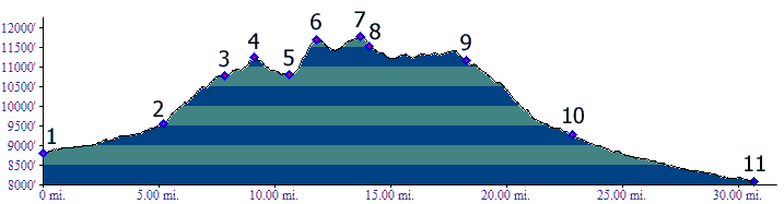
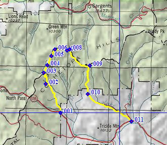
1.(8800ft,mile00) START-END WEST ALTERNATE: jct Co114 to North Cochetopa Pass - FR810
2.(9570ft,mile06) turn right onto FR790; profile between here and point 4 is an approximation
3.(10780ft,mile08) START-END WEST: start Colorado Trail, head east
4.(11200ft,mile10) intermediate summit
5.(10810ft,mile11) intermediate low point
6.(11700ft,mile12 high point below Middle Baldy
7.(11780ft,mile15) TOP: high point below Long Branch Baldy
8.(11516ft,mile15) 4 way intersection with trail north to Baldy Lake and south to Sheep Creek
9.(11160ft,mile19) START-END EAST: leave Colorado Trail and go down FR850 on right
10.(9280ft,mile23) profile turns left out of Houghland Gulch to follow Jack's Creek downstream
11.(8080ft,mile31) START-END EAST ALTERNATE: jct EE38rd - Co114 to North Cochetopa Pass