| |
|
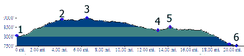
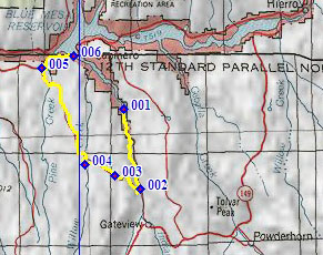
1.(8070ft,mile00) START-END NORTH: jct Co149 - turnoff
to downtown Powderhorn on left
2.(8930ft,mile04) Profile turns left onto CR26
3.(9000ft,mile17) TOP
4.(8340ft,mile12) intermediate low point
5.(8520ft,mile13) intermediate high point
6.(7600ft,mile16) CR26 merges onto US50 along Blue Mesa
Reservoir
7.(7520ft,mile21) START END SOUTH: US50 crosses Blue
Mesa Reservoir