| |
|
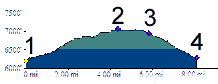
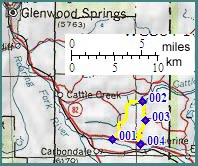
1.(6190ft,mile00) START-END WEST: jct
Co82 - Crystal Spring Road, east of Carbondale
2.(7060ft,mile05) TOP and junction with Catherine Store Road. Profile turns downhill to right.
3.(6950ft,mile06) paved road on left leads to paved descent to El Jebel
4.(6280ft,mile09) START-END EAST: jct Catherine Store Road - Co82
2.(7060ft,mile05) TOP and junction with Catherine Store Road. Profile turns downhill to right.
3.(6950ft,mile06) paved road on left leads to paved descent to El Jebel
4.(6280ft,mile09) START-END EAST: jct Catherine Store Road - Co82