| |
|
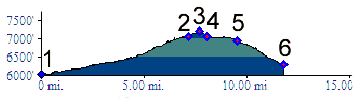
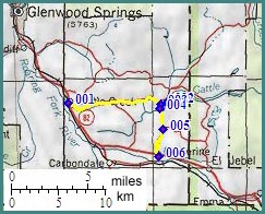
1.(6030ft,mile00) START-END NORTH: junction: Co82 - Cattle Creek Road
2.(7040ft,mile07) profile turns right at T
3.(7200ft,mile08) TOP
4.(7060ft,mile09) Crystal Spring Road (paved) on right also descends to Co82.
5.(6950ft,mile10) paved road on left also descends to Co82 via El Jebel.
6.(6280ft,mile12) START-END SOUTH: Catherine Store on Co82