| |
|
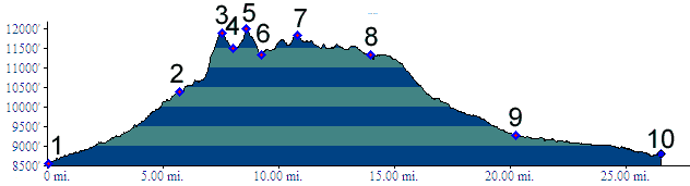
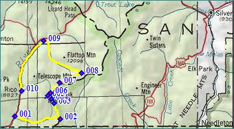
01.(8560ft,mile00) START-END SOUTH: turnoff on Co145 up Scotch Creek.
02.(10390ft,mile06) profile turns left along ridge near top of Scotch Creek Pass
03.(11890ft,mile07) intermediate high point
04.(11490ft,mile08) intermediate low point
05.(11970ft,mile09) TOP: Blackhawk Pass
06.(11330ft,mile10) intermediate low point
07.(11830ft,mile11) section point, rough dirt road from here on
08.(11330ft,mile15) route joins western approach of Bolam Pass near its top
09.(9270ft,mile21) START-END NORTH ALT: route joins paved Co150 and turns left downhill
10.(8820ft,mile27) START-END EAST: Rico