02.(09.9km,296m) route to D19 Levens(sh) joins on right
03.(11.1km,291m) route to Utelle joins on left
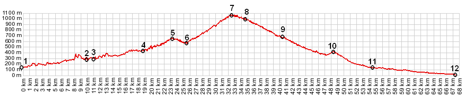
04.(18.6km,448m) START-END EAST: profile turns right, leaving the Gorge of the Vesubie
05.(23.2km,645m) intermediate high point
06.(25.6km,562m) intermediate low point, while crossing Ruisseau des Vernes
07.(32.3km,1068m) TOP: Col de Porte
08.(34.5km,990m) Col St Roche
09.(40.3km,670m) jct with route to Col de l'Orme and Col de l'Able, prior to etering Luceram
10.(48.2km,419m) Col de Nice and jct with road to Berre les Alpes s(u)
11.(54.4km,133m) START-END WEST: jct D15 - D2204, north of Cantaron
12.(67.2km,2m) START-END WEST ALT: port in Nice
View eu_Porte in a larger map |