|
|||||||||||||||||
|
|
|||||||||||||||||
| |
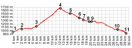
01.(00.0km,967m) START-END EAST: jct D17 - N85, west of Saint Bonnet
en Champsaur
02.(02.0km,1059m) Poligny
03.(05.9km,1134) le Villard
04.(12.1km,1664m) TOP: Col de Noyer
05.(14.7km,1520m) profile stays left at this jct
06.(17.1km,1376m) Truziaud
07.(18.1km,1331m) profile turns hard right down D17
08.(19.5km,1280m) START-END WEST: jct with road up Col de Rioupes, north of Le Pre
09.(20.3km,1283m) St Etienne en Devoluy
10.(27.1km,1042m) Saint Disdier
11.(29.4km,933m) START-END WEST ALT: jct D217 - D537, south end of Lac du Sautet
View eu_Noyer in a larger map |