|
|||||||||||||||||
|
|
|||||||||||||||||
| |
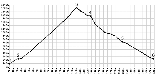
1.(80m,00.0km) START-END EAST: Torbole,
SS240 leaves rondell near center of town
2.(230m,02.3km) route turns right in Nago
3.(1710m,17.2km) TOP: pint of highest elevation, west of Monte Varagna.
4.(1470m,20.6km) Refugio Maiga Campei
5.(720m,28.9km) Bretonico
6.(230m,36.8km) START-END WEST: jct SS240 - SS3, Mori