|
|
|
|
-
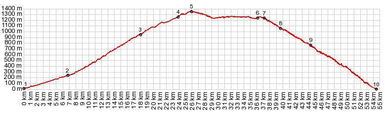
01.(00.0km,0020m)START-END EAST: Mediterranean coast in La Rabita
02.(06.7km,0240m)middle turnoff to Albunol
03.(18.0km,0950m)upper turnoff to Albondon
04.(23.9km,1260m)profile turns left along GR5204, following ridge line
05.(26.0km,1350m)TOP: point of highest elevation
06.(36.2km,1250m)turnoff downhill to Alfornon
07.(37.2km,1230m)right goes to Haza del Lino(sh), profile stays left
08.(39.8km,1060m)jct with A4131 to Sorvilan
09.(44.5km,0760m)middle turnoff to Popolos
10.(54.6km,0020m)START-END WEST: Mediterranean coast, west of La Mamola
|