|
|||||||||||||||||
|
|
|||||||||||||||||
| |
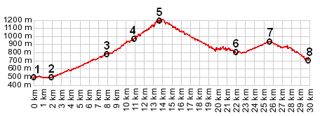
1.(00.0km,481m) START-END WEST: bridge on D22 over north west end of
Lac de Sainte Croix
2.(02.0km,490m) profile turns left onto D19
3.(07.9km,796m) Auguines
4.(11.0km,964m) Col d'Illoire
5.(13.4km,1188m) TOP: Col d'Illoire s(u)
6.(22.0km,800m) intermediate low point
7.(25.7km,961m) D71 Tunnel du Fayet s(u)
8.(29.8km,674m) START-END EAST: bridge over Canyon de l'Artuby
2.(02.0km,490m) profile turns left onto D19
3.(07.9km,796m) Auguines
4.(11.0km,964m) Col d'Illoire
5.(13.4km,1188m) TOP: Col d'Illoire s(u)
6.(22.0km,800m) intermediate low point
7.(25.7km,961m) D71 Tunnel du Fayet s(u)
8.(29.8km,674m) START-END EAST: bridge over Canyon de l'Artuby
View eu_D71_Col_d'Illoire_U in a larger map |