|
|||||||||||||||||
|
|
|||||||||||||||||
| |
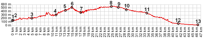
01.(00.0km,144m) just north of La Vesubie Gare
02.(00.3km,140m) START-END NORTH: profile goes up Ave Porte des Alpes towards Vesubie Gorge
03.(04.8km,203m) road from Utelle joins from right
04.(10.8km,306m) profile turns right up D19 towards Levens
05.(13.3km,432m) village of l'Imberquet
06.(14.9km,489m) intermediate summit point
07.(17.0km,387m) intermediate low point
08.(24.5km,540m) TOP: approximate summit point: D19 Levens(sh)
09.(26.4km,520m) Saint Claire
10.(28.3km,460m) Laval
11.(33.6km,357m) Saint Sebastien
12.(41.4km,56m) START-END SOUTH: road from Drap and La Trinite joins from left
13.(46.3km,3m) START-END SOUTH ALT: Nice waterfront
View D19 Levens(sh) in a larger map |