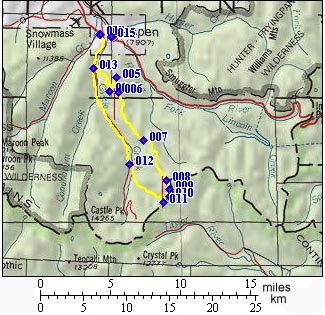
01.(m00,7910ft) START/END NORTH-EAST: downtown Aspen
02.(m01,7920ft) START-END NORTH-EAST ALTERNATE: turn left onto Castle Creek Valley road.
03.(m04,8330ft) turn left up steep dirt road up Queen's Gulch
04.(m08,10670ft) stay left at this fork
05.(m09,11220ft) go right up Richmond Hill. Route from Aspen ski area joins at this point from left.
06.(m11,11445ft) high point on Richmond Hill
07.(m15,11010ft) low point past Richmond Hill
08.(m19,12290ft) high point between Gold Hill and Ashcroft Mountain
09.(m20,11910ft) single track trail to the right cuts off the top of Taylor Pass. Profile continues straight on double track.
10.(m21,12339ft) TOP: high point on unnamed mountain above Taylor Pass. Short spur to the left leads to the top of a lookout point at 12430ft.
11.(m21,11928ft) Taylor Pass
12.(m26,9430ft) Taylor Pass road joins paved road in Castle Creek Valley. Go right
13.(m34,8330ft) same as point 3
14.(m37,7920ft) START-END NORTH-EAST ALTERNATE: same as point 2, and point 1 on principal approaches profile
15.(m37,7910ft) START/END NORTH-WEST: same as point 1